archived topics
Fachbereich
Satellitengeodäsie / Navigation
Leiter
Prof. Dr. Markus Rothacher ()
Co-Leiter/Betreuer
Dr. Roland Hohensinn ()
Dr. Gregor Möller ()
Titel
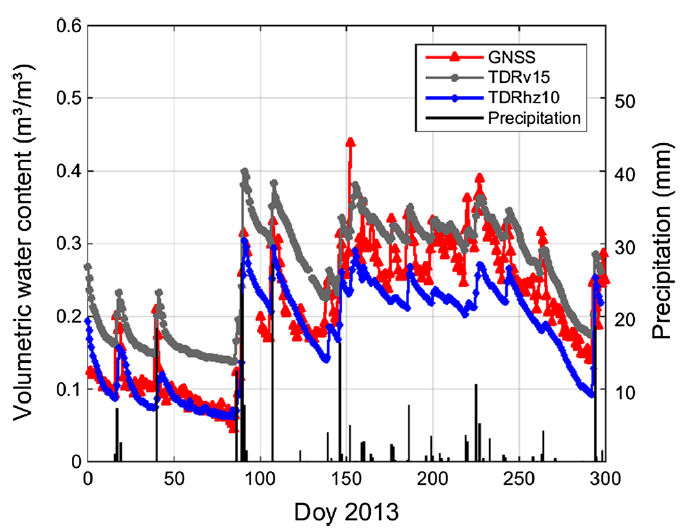
Monitoring von Niederschlagsevents mit GNSS Reflektometrie
Beschrieb
Die GNSS Reflektometrie (GNSS-R) arbeitet mit den von Reflektoren – wie Schnee, Eis oder dem Boden – zurückgeworfenen GNSS Signalen. Überlagert mit dem direkt empfangenen Signal ergibt sich in der GNSS Phasenmessung ein periodisches Interferenzmuster, welches auch im Signal-Rauschverhältnis (SNR) sichtbar ist. Ziel dieser Arbeit ist es, aus möglichst schneller Bestimmung einer Phasenänderung, welche durch Änderung der Reflexionseigen-schaften des Reflektors (in diesem Fall der Wassergehalt des Bodens) verursacht wird, ein Niederschlagsevent zu detektieren. Hierfür sollen die SNR Messungen herangezogen werden.
Die zur Auswertung notwendigen GNSS Daten sollen einerseits vom schweizerischen GNSS Permanentstationsnetzwerk (AGNES) bezogen werden, andererseits soll selbst ein Versuchsaufbau gemacht werden: Durch gleichzeitige Verwendung eines geodäti-schen Empfängers und eines low-cost-Empfängers soll die Möglichkeit evaluiert werden, mit billigen Empfängern solche Effekte nachzuweisen. Weiters besteht die Möglichkeit, GNSS-Phasenmess-ungen mit einem Android smartphone zu machen, und die Qualität des Signal-Rauschverhältnisses zur Anwendung in der GNSS-Reflektometrie zu evaluieren.
Bemerkung
Gruppenarbeit möglich
Fachbereich
GNSS Monitoring / Satellitengeodäsie
Leiter
Prof. Dr. M. Rothacher ()
Betreuer
Lukas Müller ()
Titel
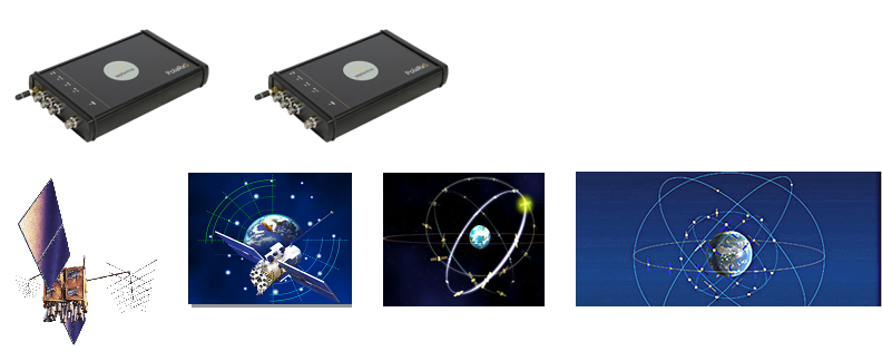
Analyse der Unterschiede in den verschiedenen GNSS-Signalen mit Hilfe von zwei Septentrio-Empfängern
Beschrieb
Motivation
Mit den zwei vom MPG erworbenen Septentrio PolaRx5 Multi-GNSS-Empfängern kann eine Vielfalt von neuen GNSS-Signalen (Code- und Phasenmessungen) untersucht werden (z.B. die speziellen Galileo-Signale E5a, E5b, und E5). Die beiden Empfänger haben je insgesamt 544 Kanäle, so dass verschiedenste Signale der GNSS gleichzeitig aufgezeichnet werden können. Mit Zero-Baselines (zwei Empfänger an einer Antenne) oder Messungen auf sehr kurzen Basislinien auf dem HPV-Dach soll die Qualität der GNSS-Messtypen untersucht werden. Dabei ist zu erwarten, dass auch systematische Unterschiede und Biases zwischen den Signalen geben wird, die quantifiziert werden sollten.
Aufgaben
Überlegen, welche GNSS-Signale für solche Untersuchungen besonders interessant sind (z.B. Galileo E5)
Aufzeichnen der GNSS-Signale auf Zero-Baselines und kurzen, bekannten Basislinien mit den multi-GNSS-Septentrio-Empfängern
Analyse der Daten mit MATLAB und RTKLIB
Bestimmen der Qualität der Messungen und allfälliger Unterschiede zwischen den Signalen (Biases).
Diskussion der Qualität der Resultate
Besonderes
Gruppenarbeit möglich
Study direction
GNSS
Chair
Prof. Dr. Markus Rothacher ()
Primary supervisors
Dr. Roland Hohensinn ()
Dr. Gregor Moeller ()
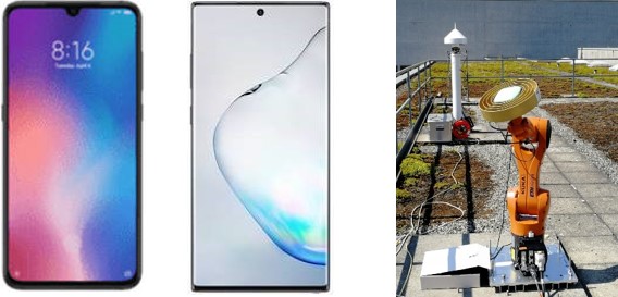
Title
Can dual-frequency GNSS receivers in smartphones be used for high-precision applications?
Overview
In the last two years smartphones have become available, that have built-in dual-frequency multi-GNSS receivers and antennas. More than 41 such smartphone models from 10 manufacturers are already on the market. Examples are the Chinese Xiaomi Mi 8 and the Galaxy Note10 from Samsung. Some of these smartphones even allow access to the original phase and code measurements and not only to position, velocity and timing of the receiver solution.
Project
It is the goal of this interdisciplinary project work to study the accuracy of the positioning results that can be obtained with smartphones and to understand, which error sources are degrading the solutions the most compared to results from geodetic GNSS equipment. Especially antenna phase center variations and multipath are crucial error sources that should be taken into consideration.
The tasks will be the study of the relevant error sources, e.g.
1) Quantification of the raw phase and code observation noise
2) Calibration of the antenna phase center of the smartphone antenna using the robot
3) The assessment of the influence of multipath on the results
Language (incl. report, oral presentation and poster)
Deutsch / English
Study direction
GNSS / Satellite Geodesy
Supervisor: Prof. Dr. Markus Rothacher ()
Advisor/further supervisor: Dr. Gregor Möller ()
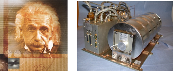
Title: Relativistic Effects in the Clocks and Orbits of the Galileo Satellites 5 and 6
Motivation:During the start of the Galileo satellites 5 and 6 a problem with the rocket occurred and the two satellites were launched into a very eccentric orbit. Because of the high eccentricity of the orbits and the fact, that these satellites carry extremely precise clocks, so-called passive hydrogen masers, on board, these satellites are very well-suited to study the influence of relativistic effects on the clocks and orbits of these two satellites. The main effects are: moving clocks are ticking more slowly and clocks in a stronger gravity field are also running more slowly. How large are these relativistic effects and how well can relativistic parameters be estimated from the clock data ?
Long time series of satellite clock corrections and orbit positions are available for the Galileo satellites 5 and 6 from the analysis of the large global network of GNSS stations.
Tasks
Simulate the size of the expected effects by using the Bernese GNSS software and compare these values with the formulas available.
Compare the size of the clock effects with real clock corrections available from a global network solution.
Derive relativistic parameters based on the satellite clock corrections for the Galileo satellites 5 and 8 and compare them with values given in the literature.
Particularities: This work can be carried out by a group. Max. number of students: 2
Study direction:GNSS / Satellite Geodesy
Supervisor: Prof. Dr. Markus Rothacher ()
Advisors / further supervisors: Dr. Gregor Möller () and Kangkang Chen ()
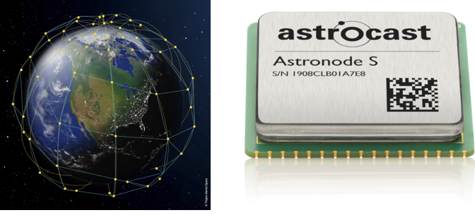
Title:Positioning of the Astrocast ground terminals with Doppler measurements collected onboard the Astrocast satellite constellation
Abstract: Astrocast is presently building up a constellation of 3-unit cube satellites (10 cm x 10 cm x 30 cm) for the Internet of Things (IoT), i.e. for the communication of small amounts of data from anywhere on the Earth surface to one of the Astrocast constellation satellites using a small user terminal on ground. The satellite will then download the data to a ground station, from where the data is put into an internet cloud area for the user. Astrocast would now like to determine the position of the user terminals without having to equip them with a GNSS receiver.
It is the goal of this thesis, therefore, to study the possibility to use Doppler measurements on the satellites of the constellation to derive the position of the terminal that was used to send the signals to the satellites.
Tasks
Develop a program to compute the Doppler shift in the communication frequency to be expected for a given terminal position and velocity and a given satellite position and velocity.
Study the terminal locations on the Earth that would produce a given Doppler shift including the error of the Doppler measurement onboard the satellite.
Study, how many satellite passes (communication events) are required to get a certain positioning accuracy for the terminal, depending on the satellite geometry and the error in the Doppler measurements.
Interpretation of the results obtained
Particularities: This work can be carried out by a group. Max. number of students: 2
Study direction: GNSS / Satellite Geodesy
Supervisor: Prof. Dr. Markus Rothacher ()
Advisors /further supervisors: Dr. Roland Hohensinn () and Iván Herrera Pinzón ()
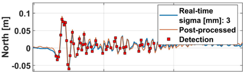
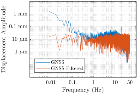
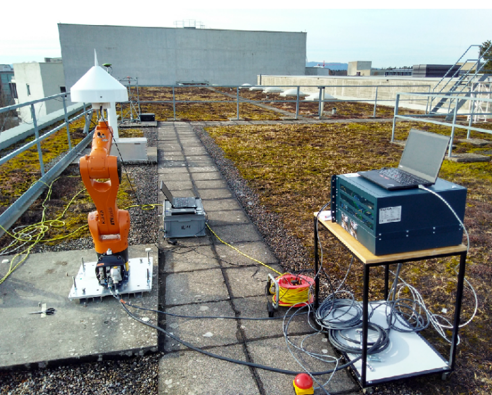
Title: A Kalman filter for the real-time detection of very small displacements from GNSS data
Abstract: With high-precision GNSS we can resolve ground movements with magnitudes at the millimeter level, and even below. This could be highly-dynamic processes like earthquake-induced ground motions and high-frequent vibrations of structures, or rather low-dynamic processes like plate motions, for example, . In any case, we would like to detect changes as fast as possible, so that natural hazard early warning systems could be augmented with this information.
This work aims at setting up a Kalman filter that is capable of estimating and predicting the parameters of a standard ground motion trajectory model (consisting of discontinuities and periodic motions). Based on a statistical test, the estimated parameters should be tested for significance then. Furthermore, the Kalman filter should be augmented by a noise shaping filter, so that remaining GNSS effects like multipath can be separated from the real movement.
For obtaining test data, both existing data from permanent GNSS networks, as well as data obtained by an experiment with a high-rate GNSS mounted on the KUKA robot arm should be used. For the experiment, a focus should be put on using the institutes’ low-cost GNSS dataloggers, and a real-time Precise-Point-Positioning solution should be computed. In case there is interest, it could also be analyzed how these solutions could improve near-real-time earthquake magnitude estimation, e.g. for Switzerland.
Particularities
This work can be carried out by a group. Max. number of students: 2
Study direction: GNSS / Satellite Geodesy
Supervisor: Prof. Dr. Markus Rothacher ()
Advisors/further supervisors: Roland Hohensinn ()
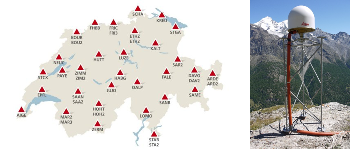
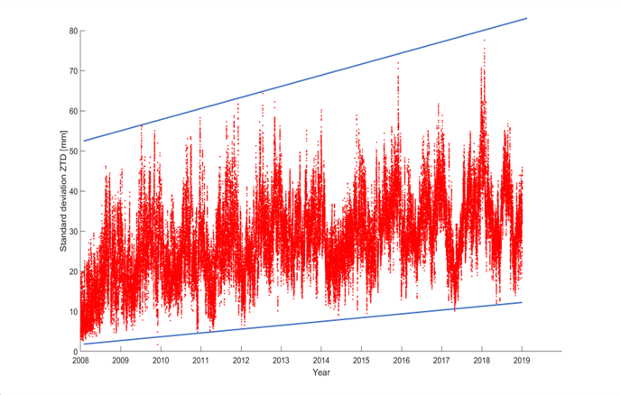
Title: Analysis of GNSS-derived Tropospheric Delays over Switzerland
Abstract: Troposhperic path delays, and their variability on short and long terms relate directly to changes of both, the weather and the climate. The Swiss Federal Bureau of Topography swisstopo maintains a dense network of GNSS reference stations and computes zenith tropospheric delays on a regular, hourly basis. For many stations, the datasets available span intervals of more than twenty years.
The aim of this thesis is, on the one hand, to do a time series analysis of these datasets. The individual series shall be decomposed into components, which are a trend, periodic effects and irregular (random) fluctuations -- hand-in-hand, the characteristics of the random component shall be analyzed and modelled. Based on this, a trend as well as the coefficients of a periodic model can be estimated by means of least squares regression methods. In the following, the estimated parameters can be tested for significance. Special emphasis shall be put on the detectability of long-term trends in water vapor from these time series: Given the distribution of the noise and the length of the series, an expression for a minimum detectable magnitude of the trend component can be derived. To the end, the results obtained for the individual station parameters (like trend and periodic amplitudes) shall be studied with regard to attributes of the station location, like topographic height. Furthermore, it could also be assessed how the satellite geometry can affect the estimates – also with regard to the station height, since troposphere and station height are strongly correlated.
Particularities: This work can be carried out by a group. Max. number of students: 2