Reference frames and timing
Reference frames, tied to the Earth or to inertial space, are the crucial basis for all Earth observation, global change and monitoring activities and timing is at the heart of space geodesy, since practically all high-precision observations involve time or frequency measurements. We realize highly accurate reference frames by reprocessing GNSS observation over decades and we try to make use of very stable clocks like H-masers and, in future, optical clocks, to improve the GNSS analysis and positioning.
Project list:
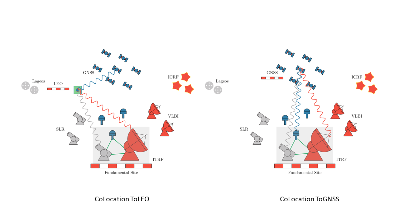
Co-location of Space Geodetic Techniques on Ground and in Space
The goal of the project "Co-location of Space Geodetic Techniques on Ground and in Space" is the improvement of existing and the establishment of new ties between the space geodetic techniques both on ground and in space, to achieve the realisation of a common reference frame able to meet the growing requirements of modern users.
The goal of this project is composed by two main tasks:
1. The study of measurements between instruments of the same space geodetic technique, intra-technique co-location, to improve the understanding of system-specific error sources. The aim of this part of the project is to collect data from three techniques on very short local baselines (SLR-SLR, VLBI-VLBI and GNSS-GNSS) to test and evaluate new measurement concepts and processing strategies (e.g. SLR single- and double-differences and VLBI observation of GNSS satellites) and to assess error sources for each individual technique
2. The study of simultaneous measurements of GNSS and Low Earth Orbit
(LEO) satellites from VLBI and SLR (inter-technique co-location), to investigate systematic biases and local tie accuracy.
These experiments will be complemented on the Earth by observing a new common reference target available at the Geodetic Observatory in Wettzell (Germany), where a common clock can be used to generate new "clock'' ties. These elements constitute a setup that will lead to a significant step in the analyses of technique-specific biases. Various studies will be performed using the VLBI observations of GNSS satellites
(G-VLBI) and LEO satellites. Using common parameters between the three space techniques, these techniques will be studied and a rigorous combination at the observation level will be intended, achieving highest consistency by using common models and parametrisation.
Start date:
01.10.2015 - 30.09.2018
Project partners:
TU Munich, BKG, Wettzell
Contacts at MPG:
Markus Rothacher ()
Iván Herrera Pinzón ()
Financiers (external):
SNF swiss national science foundation
Links:
-